
Trip summary
At times it seems there is always a reason not to go away on a trip as originally planned, but this time there was. So the three week plan from 04 January picking off Long Fell & Tinside Rigg, thereby completing the English & Welsh Nuttalls (again) on the way north, then bagging 49 hills in Area 28 of which 23 are Marilyns has became - the one week plan starting from 19 January around Newcastleton doing as many Marilyns on the original plan and seeing how far I get.
Well here I am on 26 January at the end of the trip squeezing out six walking days, albeit the last 2 days involved only short walks and a latish start and just the 1 rest day on day 4, managed a total of 27 hills and 14 Marilyns including one repeat on Capel Fell, first walked January 2015. Must say I am very pleased with that though I do not think I can extrapolate these figures and expect to do 42 Marilyns in three weeks.
Because I only had 7 walking days I probably missed out on a rest day walking 6 days in total. Rest days are always an important part of any of my plans, strategically placed depending on the intensity of walks to aid recovery and ensure the necessary strength and endurance for subsequent walks. It seems two rest days out of seven works best for me but having exactly a seven walking day trip tempted me to make do with one rest day. The outcome was that start times became progressively later as the week went on and perhaps I could have managed one more day even if it involved another late start. But that would have been it and definitely would have needed more than 1 day recovery time to take on a significant walk involving a Munro or indeed something like the Andrewhinney Ridge involving the full day in excess of 10 miles and more than 1000m of ascent.
There it is again that magic rule of thumb. Any walk over 5/6 hours with a greater ratio of 100 metres per mile is a tough walk.
Day 01 Thursday 19 January 2017
Well here I am on 26 January at the end of the trip squeezing out six walking days, albeit the last 2 days involved only short walks and a latish start and just the 1 rest day on day 4, managed a total of 27 hills and 14 Marilyns including one repeat on Capel Fell, first walked January 2015. Must say I am very pleased with that though I do not think I can extrapolate these figures and expect to do 42 Marilyns in three weeks.
Because I only had 7 walking days I probably missed out on a rest day walking 6 days in total. Rest days are always an important part of any of my plans, strategically placed depending on the intensity of walks to aid recovery and ensure the necessary strength and endurance for subsequent walks. It seems two rest days out of seven works best for me but having exactly a seven walking day trip tempted me to make do with one rest day. The outcome was that start times became progressively later as the week went on and perhaps I could have managed one more day even if it involved another late start. But that would have been it and definitely would have needed more than 1 day recovery time to take on a significant walk involving a Munro or indeed something like the Andrewhinney Ridge involving the full day in excess of 10 miles and more than 1000m of ascent.
There it is again that magic rule of thumb. Any walk over 5/6 hours with a greater ratio of 100 metres per mile is a tough walk.
Three Marilyns planned today on this the first day of a Marilyn bagging trip north of the border based at Lidalia Touring Caravan Park. Just so happens that the first Marilyn was Peel Fell and just on or just over the other side of the border in England. Both Peel Fell and Sighty Crag are fairly remote by English standards so it made sense to pick both of these summits up even though they were not on the original plan. The other two Marilyns planned were Larriston Fells and Blackwood Hill. Though having told myself if I was not down Larriston Fell by 3pm and returning back at van at 15:15 I stuck to my word and returned back to the campsite. Correct decision but setting the scene for the trip seemingly being one hill short each day. Maybe something to do with too ambitious a plan combined with adding the two extra hills of Peel Fell and Sighty Crag
Walk Statistics
Walk Date - 19 January 2017
Walkers - Steve Smith
Accommodation - Lidalia Caravan Club Affiliated Site, Newcastleton
Start Point - Various (see maps below)
Finish Point - Various (see maps below)
Total Duration - 4hrs 51mins
Overall Average pace - 2.38mph
Total Distance Walked - 11.53 miles
Total Height Ascended - 846.72metres
Peaks visited
Marilyns (175E, 1218S - 1556E,W&S)
Peel Fell (120E - 301E,W&S)
Larriston Fells (61S - 302E,W&S)
Deweys (180E - 421E&W)
Peel Fell (58E - 124E&W)
Donald Deweys (248S)
Larriston Fells (14S)
HuMPs (444E, 2168S - 2975EW&S)
E,W&S:England,Wales & Scotland
Walkers - Steve Smith
Accommodation - Lidalia Caravan Club Affiliated Site, Newcastleton
Start Point - Various (see maps below)
Finish Point - Various (see maps below)
Total Duration - 4hrs 51mins
Overall Average pace - 2.38mph
Total Distance Walked - 11.53 miles
Total Height Ascended - 846.72metres
Peaks visited
Marilyns (175E, 1218S - 1556E,W&S)
Peel Fell (120E - 301E,W&S)
Larriston Fells (61S - 302E,W&S)
Deweys (180E - 421E&W)
Peel Fell (58E - 124E&W)
Donald Deweys (248S)
Larriston Fells (14S)
HuMPs (444E, 2168S - 2975EW&S)
Peel Fell (165E - 389E,W&S)
Larriston Fells (74S - 390E,W&S)
Historic County Tops (413E - 93E,W&S)
NONE
Larriston Fells (74S - 390E,W&S)
Historic County Tops (413E - 93E,W&S)
NONE
W: Wales.
E,W: England & Wales. E,W&S:England,Wales & Scotland
Peel Fell
5.89 miles, 437.94m ascent, Start Time 09:52am, Finish Time 12:16pm, 2 hours 24 minutes, 2.45 mph
Convenient parking in layby opposite forestry road NW of Kittythirst Cottage (NY 60832 96437). 2.7 mile route planned straight up and return by same route. Slight detour on ascent by incorrectly sticking to main path and heading for Deadwater Fell, having been seduced by the golf ball/radio station visible off to the right. Error soon corrected returning to planned track by taking alternative forest track heading NE.
Returned planned ascent route though do have mixed feelings about not picking off the Dewey Deadwater Fell and the sub-Dewey Mid Fell. But here to do Marilyns and wanted to give myself the chance to complete two remaining Marilyns despite the late start and short daylight hours.
Larriston Fells
5.64 miles, 408.78m ascent, Start Time 12:48pm, Finish Time 15:15pm, 2 hours 27 minutes, 2.30 mph
Parked off road along fence near forestry road entrance opposite Hewsbridge Cottage (NY 53690 93184). Straight forward up and down route to radio station near 482m spot height though did miss first firebreak above harvested part of plantation, then on to summit and trig pillar via 500m contour ring. No obvious path from radio station so descended following a track heading east from the trig pillar. Did not go in the direction required so cut NW through grassy hillside that had been prepared for tree planting by some massive dibber.
Day 02 Friday 20 January 2017
 |
| Approaching from the SW and approx ½ hour after emerging from plantation - Peel Fell summit comes in to view
Click on photograph to view slide-show
|
 |
GPX can be downloaded from www.shareyouradventure.com |
Convenient parking in layby opposite forestry road NW of Kittythirst Cottage (NY 60832 96437). 2.7 mile route planned straight up and return by same route. Slight detour on ascent by incorrectly sticking to main path and heading for Deadwater Fell, having been seduced by the golf ball/radio station visible off to the right. Error soon corrected returning to planned track by taking alternative forest track heading NE.
Returned planned ascent route though do have mixed feelings about not picking off the Dewey Deadwater Fell and the sub-Dewey Mid Fell. But here to do Marilyns and wanted to give myself the chance to complete two remaining Marilyns despite the late start and short daylight hours.
 |
| Larriston Fell trig pillar visible from Cairn on 500m contour ring to the SW
Click on photograph to view slide-show
|
 |
GPX can be downloaded from www.shareyouradventure.com |
Parked off road along fence near forestry road entrance opposite Hewsbridge Cottage (NY 53690 93184). Straight forward up and down route to radio station near 482m spot height though did miss first firebreak above harvested part of plantation, then on to summit and trig pillar via 500m contour ring. No obvious path from radio station so descended following a track heading east from the trig pillar. Did not go in the direction required so cut NW through grassy hillside that had been prepared for tree planting by some massive dibber.
Day 02 Friday 20 January 2017
Just two walks planned today but increased to three to include Blackwood Hill which I did not have time for yesterday. Thing is if I am going to have any chance of including the extra walk without compromising the two already planned I really must get an earlier start. I did not so although only the one walk not completed it was the one with two Marilyns, so after two days now two Marilyns behind schedule.
Walk Statistics
4.54 miles, 330.37m ascent, Start Time 09:58am, Finish Time 11:58am, 2 hours 00 minutes, 2.27 mph
Start point at entrance to forestry track near Taylor's Cleuch on Steele Road (NY 53208 93833) just round corner from start point for Larriston Fell so would have been ideal to do as a separate walk on same day. Walked north up forest track through harvested plantation following it to the right where it picks up dismantled railway bed. Turned left off track at Bught Knowe heading up hill looking for fire break to gain summit ridge. Nothing obvious but found gap in trees more or less where shown on map which leads to forest boundary approx. 400m south of summit. Followed fence to summit where met a farmer on his quad bike who told me summit was at trig on Arnton Fell. Hill-bagging tells me it is not the summit but being so close took the opportunity to bag the trig pillar just over 1 mile to SW along fence from Blackwood Hill summit.
Descending from trig pillar to the SE picking up plantation boundary made for a preferred circular walk and return to van.
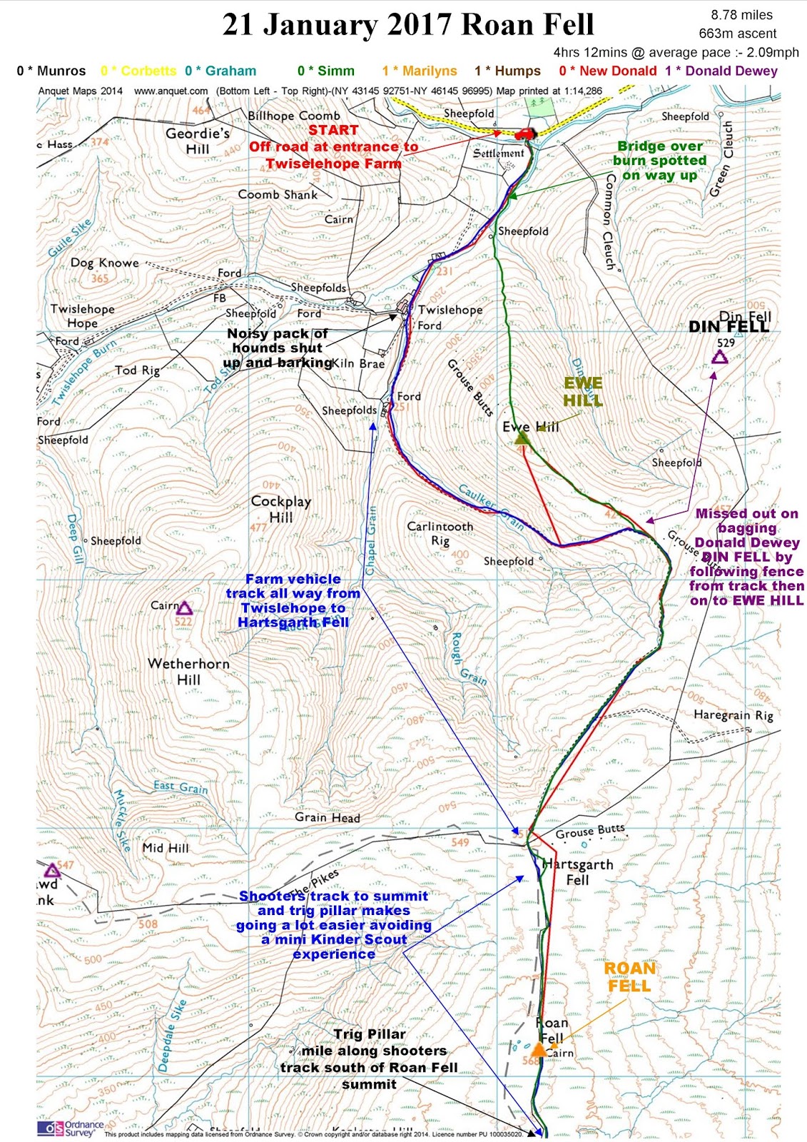
Roan Fell
7.37 miles, 464.07m ascent, Start Time 12:49pm, Finish Time 15:42pm, 2 hours 53 minutes, 2.56 mph
Parked on roadside at entrance to Twiselehope Farm (NY 45111 96794) following access drive to farm then beyond up track between Ewe Hill on left and Carlintooth Rig on right to fence and 551m spot height at Hartsgart Fell.
Expected a mini Kinder Scout experience from here following fence to summit, however thanks to our shooting friends a rough composite mud/stone track been laid following fence line to summit and ¾ mile beyond to the trig pillar.
Absolute blessing given terrain and poor visibility of the day.
Descended via same route until taking small diversion to the right off track on way down from Roan Fell to pick off Ewe Hill then continuing over the top, dropping below cloud line and returning to van after crossing burn over bridge spotted on ascent.
Could have quite easily picked off Donald Dewey - Din Fell before Ewe Hill by following fence north from track. Unfortunately did not.
Day 03 Saturday 21 January 2017
First multi-Marilyn day up Cauldcleuch Head & Greatmoor Hill and first time ventured above 2000' north of the border since Croft Head back in December 2015
Ellson Fell
7.37 miles, 464.07m ascent, Start Time 12:49pm, Finish Time 15:42pm, 2 hours 53 minutes, 2.56 mph
A quick short walk squeezed in at the end of a short winter day after Cauldcleuch Head & Greatmoor Hill. Short drive along road from Braidlie and Hermitage Castle. Parked on grass at back of passing place east of over Carsemungo Sike. Straight in to ascent up March Shank to first summit when notice cloud starting to gather around Ellson Fell. Bright sunshine, blue skies and ochre ground cover is soon replaced by low cloud by the time the first summit of Ellson Fell South Top is reached. Descend summit following path to NE down to saddle and on to Ellson Fell summit approached from the SE. No time to hang around in fog head back and down seeking descent route down southern tongue until clear cloud line where can see van parked below. Plan was to return over Tup Knowe but did not fancy the steep ascent up north side so continued heading down following Carsemungo Sike to the west of Tup Knowe back to the van
Day 04 Sunday 22 January 2017
Walk Statistics
Walk Date - 20 January 2017
Walkers - Steve Smith
Accommodation - Lidalia Caravan Club Affiliated Site, Newcastleton
Start Point - Various (see maps below)
Finish Point - Various (see maps below)
Total Duration - 4hrs 53mins
Overall Average pace - 2.44mph
Total Distance Walked - 11.91 miles
Total Height Ascended - 794.44metres
Peaks visited
Marilyns (1218S - 1556E,W&S)
Blackwood Hill (62S - 303E,W&S)
Roan Fell (63S - 304E,W&S)
Donald Deweys (248S)
Roan Fell (15S)
HuMPs (2168W - 2975EW&S)
E,W&S:England,Wales & Scotland
Blackwood HillWalkers - Steve Smith
Accommodation - Lidalia Caravan Club Affiliated Site, Newcastleton
Start Point - Various (see maps below)
Finish Point - Various (see maps below)
Total Duration - 4hrs 53mins
Overall Average pace - 2.44mph
Total Distance Walked - 11.91 miles
Total Height Ascended - 794.44metres
Peaks visited
Marilyns (1218S - 1556E,W&S)
Blackwood Hill (62S - 303E,W&S)
Roan Fell (63S - 304E,W&S)
Donald Deweys (248S)
Roan Fell (15S)
HuMPs (2168W - 2975EW&S)
Blackwood Hill (75S - 391E,W&S)
Roan Fell [Mynydd Eppynt] (76S - 392E,W&S)
Historic County Tops (413E - 93E,W&S)
NONE
Roan Fell [Mynydd Eppynt] (76S - 392E,W&S)
Historic County Tops (413E - 93E,W&S)
NONE
W: Wales.
E,W: England & Wales. E,W&S:England,Wales & Scotland
 |
| Arnton Fell trig pillar. Just a short diversion 1 mile to the SE from Blackwood Hill summit
Click on photograph to view slide-show
|
 |
GPX can be downloaded from www.shareyouradventure.com |
Start point at entrance to forestry track near Taylor's Cleuch on Steele Road (NY 53208 93833) just round corner from start point for Larriston Fell so would have been ideal to do as a separate walk on same day. Walked north up forest track through harvested plantation following it to the right where it picks up dismantled railway bed. Turned left off track at Bught Knowe heading up hill looking for fire break to gain summit ridge. Nothing obvious but found gap in trees more or less where shown on map which leads to forest boundary approx. 400m south of summit. Followed fence to summit where met a farmer on his quad bike who told me summit was at trig on Arnton Fell. Hill-bagging tells me it is not the summit but being so close took the opportunity to bag the trig pillar just over 1 mile to SW along fence from Blackwood Hill summit.
Descending from trig pillar to the SE picking up plantation boundary made for a preferred circular walk and return to van.
 |
| Roan Fell access over bridge to Twiselehope Farm visible through trees centre left
Click on photograph to view slide-show
|
 |
GPX can be downloaded from www.shareyouradventure.com |
Parked on roadside at entrance to Twiselehope Farm (NY 45111 96794) following access drive to farm then beyond up track between Ewe Hill on left and Carlintooth Rig on right to fence and 551m spot height at Hartsgart Fell.
Expected a mini Kinder Scout experience from here following fence to summit, however thanks to our shooting friends a rough composite mud/stone track been laid following fence line to summit and ¾ mile beyond to the trig pillar.
Absolute blessing given terrain and poor visibility of the day.
Descended via same route until taking small diversion to the right off track on way down from Roan Fell to pick off Ewe Hill then continuing over the top, dropping below cloud line and returning to van after crossing burn over bridge spotted on ascent.
Could have quite easily picked off Donald Dewey - Din Fell before Ewe Hill by following fence north from track. Unfortunately did not.
First multi-Marilyn day up Cauldcleuch Head & Greatmoor Hill and first time ventured above 2000' north of the border since Croft Head back in December 2015
Ellson Fell
 |
| Bright late afternoon sunshine in January heading up Ellson Fell South Top centre left
Click on photograph to view slide-show
|
 |
GPX can be downloaded from www.shareyouradventure.com |
A quick short walk squeezed in at the end of a short winter day after Cauldcleuch Head & Greatmoor Hill. Short drive along road from Braidlie and Hermitage Castle. Parked on grass at back of passing place east of over Carsemungo Sike. Straight in to ascent up March Shank to first summit when notice cloud starting to gather around Ellson Fell. Bright sunshine, blue skies and ochre ground cover is soon replaced by low cloud by the time the first summit of Ellson Fell South Top is reached. Descend summit following path to NE down to saddle and on to Ellson Fell summit approached from the SE. No time to hang around in fog head back and down seeking descent route down southern tongue until clear cloud line where can see van parked below. Plan was to return over Tup Knowe but did not fancy the steep ascent up north side so continued heading down following Carsemungo Sike to the west of Tup Knowe back to the van
Well earned rest day and transfer from Lidalia Caravan Club Affiliated Site, Newcastleton to Moffat Caravan & Camping Club site, Moffat.
Day 05 Monday 23 January 2017
Day 05 Monday 23 January 2017
Just the one new Marilyn which happens to venture above 2000' and into Graham and Donald hill categories. Chance to tick off 12 summits along The Andrewhinney Ridge facilitated by an end to end walk in the good company of Marilyn completers Rick Salter and Jenny Hatfield.
Really should team up with fellow hill baggers more often.
Day 06 Tuesday 24 January 2017
White Meldon
1.70 miles, 210.36m ascent, Start Time 12:54pm, Finish Time 13:48pm, 0 hours 54 minutes, 1.89 mph
After turning left off the A72 and driving north up the road alongside Meldon Burn decided to stop and park off road at the picnic spot SW and in sight of White Meldon rather than driving further and parking near the cattle grid to its west. Having first walked away from White Meldon to find the bridge over Meldon Burn. Eventually found a vague path heading towards summit that turned east parallel the summit Continued following the track expecting it to turn left which it did leading to summit cairn and high point which is actually the trig pillar slightly east of the cairn. Could have returned the same way but left summit heading west following path through heather and down fairly steep descent to cattle grid, original planned start point where there is in fact parking and a public toilet.
Cademuir Hill
1.57 miles, 181.39m ascent, Start Time 14:19pm, Finish Time 15:13pm, 0 hours 54 minutes, 1.74 mph
Just a short up and down route planned from Cademuir car park just south of Peebles. Forestry harvesting disrupted that plan but was still able to find remnants of original firebreak to reach summit rim. From there it was a case of finding best route through tree stumps to summit which was in progress of being turned in to a picnic sight. Decided to descend following newly constructed path to afore mentioned picnic area but very soon it started heading NW away from where I wanted to be. Maybe it does loop round to return to forest track back to car park but decided not to chance it and cut through trees downhill to pick up track and return to van.
Day 07 Wednesday 25 January 2017
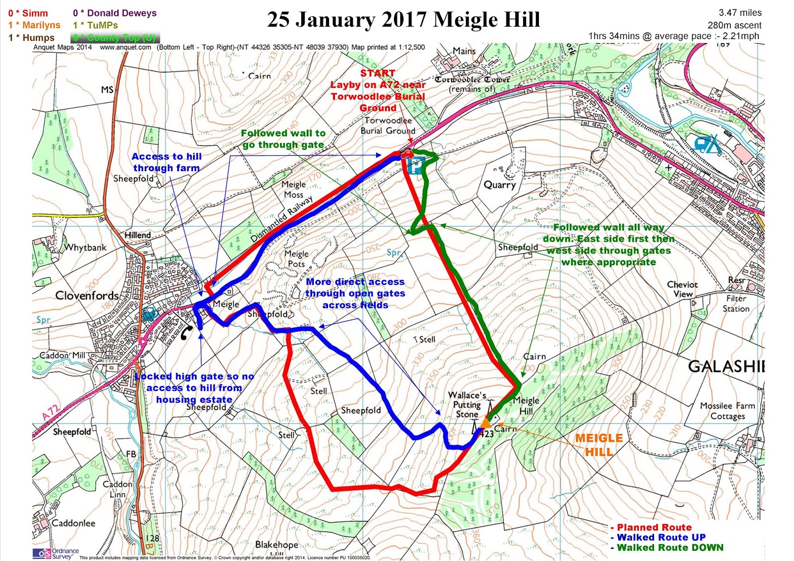
Meigle Hill
3.47 miles, 279.53m ascent, Start Time 11:21am, Finish Time 12:55pm, 1 hours 34 minutes, 2.21 mph
Starting from car park/layby near Torwoodlee Burial Ground headed towards Clovenwoods along footpath at side of road. Unsure about access through Meigl Farm tried to gain hill and open country through new housing estate and although found gate at end of path at side of house, it was locked and not really suitable to climb over. So returned to farm and found what is probably intended access to hill. Farm track loops west and south leading to summit but took more direct route thogh open gates across fields. Summit is just beyond NE of radio mastsnear wall and trig pillar. Shorter return route by following wall to NE of trig pillar more or less directly down back to layby and van on A72
Black Hill
1.70 miles, 175.10m ascent, Start Time 13:29pm, Finish Time 14:25pm, 0 hours 56 minutes, 1.82 mph
Quite a distinctive prominant hill. Parked on Earlsdon Road offroad at entrance to permissive path signed to Black Hill. Looks like it is provided by land owner to avoid using private access to Cowdenknowe Mains on the other side of trees. Well signed right up to base of hill but did not see any further signs.
Continued around western flank expecting to find path turning left directly up hill. Did not find one so turned left anyway finding route with least gradient through dead fern, may be thicker in summer. Did find a track spiralling around ancient ramparts and found way to trig point and grassy summit. attempted to find path down but nothing really obvious so simply headed down (fairly steep in places avoiding thick bracken) in direction of known track back to Cowdenknowe Mains then back to van.
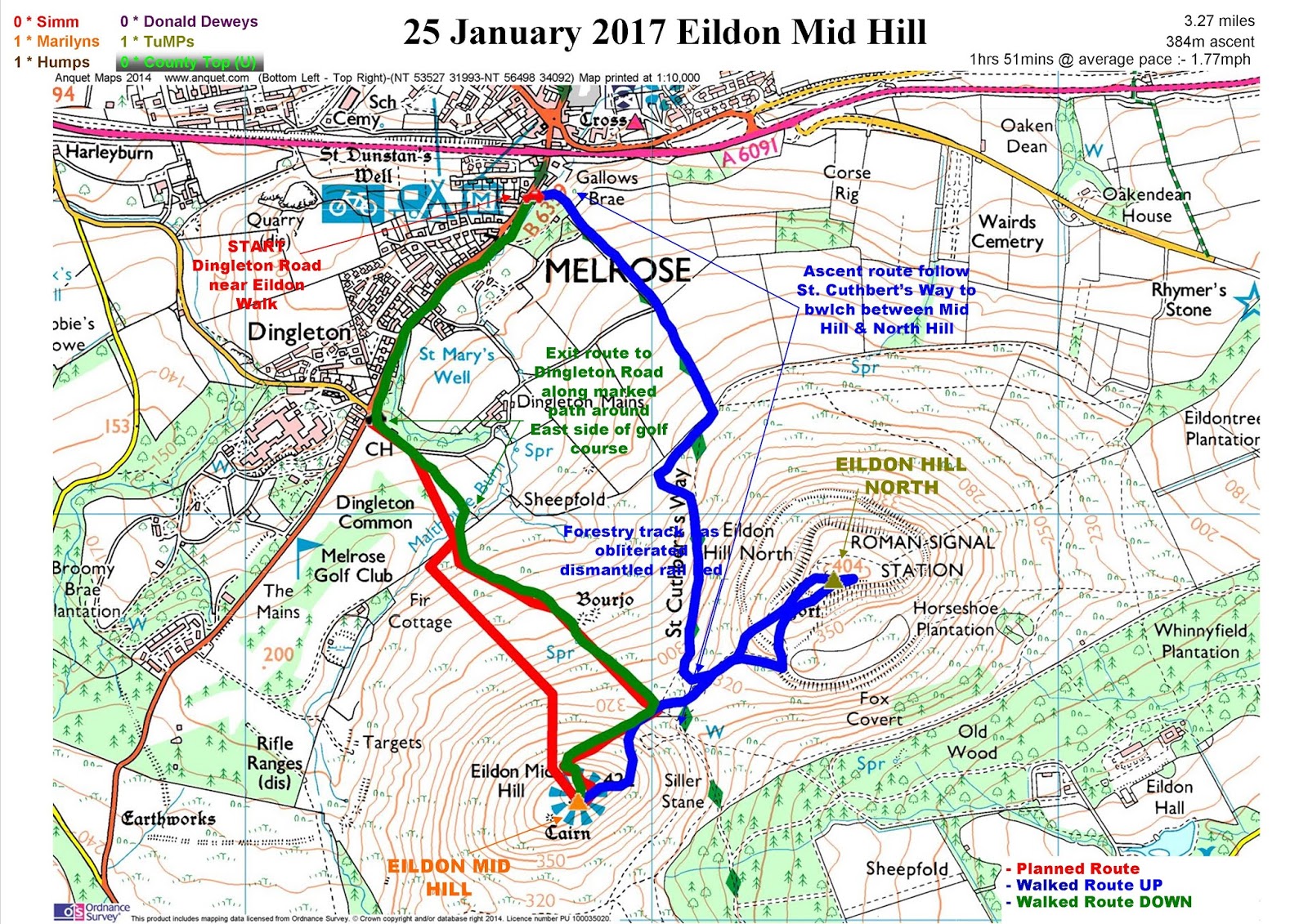
Eildon Mid Hill
3.27 miles, 384.45m ascent, Start Time 15:04pm, Finish Time 16:55pm, 1 hours 51 minutes, 1.77 mph
No direct access on to B6359 from A6091 other than from Melrose. Parked on Dingleton Road near Eildon Walk.
Followed St. Cuthbert's Walk down alley and up steep steps continuing to follow it to bwlch between Eildon Hill North and Eildon Mid Hill. Although only a TUMP could not resist going to Eildon Hill North first. More or less a there and back divertion before continuing up steep sides of Eildon Mid Hill. Choice of routes, I took the left fork rewarding me with a silhouette view of trig pillar and toposcope as I emerged on the summit looking towards the setting sun. Returned to Dingleton Road via he golf course without any issues. Due to late hour nobody playing golf or indeed in clubhouse but do not anticipate a problem if stick to clearly marked path around NE side of course.
Really should team up with fellow hill baggers more often.
Day 06 Tuesday 24 January 2017
Moving day again today and after yesterdays exertions on the longest walk of the trip so far along The Andrewhinney Ridge was tempted to make this a rest day. However would have been a waste of time, diesel and opportunity if I did not pick off White Meldon, Cademuir Hill and Eildon Mid Hill whilst passing on the journey from Moffat to Galashiels. Managed the first two with relatively short walks and was still on for Eildon Mid Hill but after its dark conical shaddow looming over Galashiels on from the westerly approach along the A6091 decided to leave it for another day.
Walk Statistics
Walk Statistics
Walk Date - 24 January 2017
Walkers - Steve Smith
Accommodation - Gibson Park Caravan Club Site, Melrose
Start Point - Various (see maps below)
Finish Point - Various (see maps below)
Total Duration - 1hrs 48mins
Overall Average pace - 1.82mph
Total Distance Walked - 3.27 miles
Total Height Ascended - 391.75metres
Peaks visited
Marilyns (1218S - 1556E,W&S)
Meldon Hill (68S - 309E,W&S)
Cademuir Hill (69S - 310E,W&S)
Donald Deweys (248S)
NONE
HuMPs (2168W - 2975EW&S)
Meldon Hill (82S - 398E,W&S)
Cademuir Hill (83S - 399E,W&S)
Historic County Tops (413E - 93E,W&S)
NONE
Cademuir Hill (83S - 399E,W&S)
Historic County Tops (413E - 93E,W&S)
NONE
S: Scotland
E,W&S:England,Wales & ScotlandWhite Meldon
 |
| Looking south along Meldon Burn between Black Meldon and South Hill Head from descent down White Meldon Click on photograph to view slide-show |
 |
GPX can be downloaded from www.shareyouradventure.com |
After turning left off the A72 and driving north up the road alongside Meldon Burn decided to stop and park off road at the picnic spot SW and in sight of White Meldon rather than driving further and parking near the cattle grid to its west. Having first walked away from White Meldon to find the bridge over Meldon Burn. Eventually found a vague path heading towards summit that turned east parallel the summit Continued following the track expecting it to turn left which it did leading to summit cairn and high point which is actually the trig pillar slightly east of the cairn. Could have returned the same way but left summit heading west following path through heather and down fairly steep descent to cattle grid, original planned start point where there is in fact parking and a public toilet.
Cademuir Hill
 |
| Looking towards Peebles descending through tree stumps on descent down Cademuir Hill
Click on photograph to view slide-show
|
 |
GPX can be downloaded from www.shareyouradventure.com |
Just a short up and down route planned from Cademuir car park just south of Peebles. Forestry harvesting disrupted that plan but was still able to find remnants of original firebreak to reach summit rim. From there it was a case of finding best route through tree stumps to summit which was in progress of being turned in to a picnic sight. Decided to descend following newly constructed path to afore mentioned picnic area but very soon it started heading NW away from where I wanted to be. Maybe it does loop round to return to forest track back to car park but decided not to chance it and cut through trees downhill to pick up track and return to van.
Last day bagging before driving to Edinburgh tomorrow and picking up my darling Gina from Edinburgh station .
Three hills planned today to bring trip total to 13 and GB Marilyn total to 313; Meigle Hill, Black Hill & Eildon Mid Hill.
Long way short of monthly total of 30 to be on schedule to complete 300 Marilyns by the end of the year but hey ho just need to do 47 next month. Joking - like I said before it is not a race or a treadmill, but if you do not set a target of some description life just passes you by.
Walk Statistics
Walk Date - 25 January 2017
Walkers - Steve Smith
Accommodation - Gibson Park Caravan Club Site, Melrose
Start Point - Various (see maps below)
Finish Point - Various (see maps below)
Total Duration - 4hrs 21mins
Overall Average pace - 1.94mph
Total Distance Walked - 8.44 miles
Total Height Ascended - 839.08metres
Peaks visited
Marilyns (1218S - 1556E,W&S)
Meigle Hill (70S - 311E,W&S)
Black Hill (71S - 312E,W&S)
Eildon Mid Hill (72S - 313E,W&S)
Donald Deweys (248S)
NONE
HuMPs (2168W - 2975EW&S)
Meigle Hill (84S - 400E,W&S)
Black Hill (85S - 401E,W&S)
Eildon Mid Hill (86S - 402E,W&S)
Historic County Tops (413E - 93E,W&S)
NONE
Black Hill (85S - 401E,W&S)
Eildon Mid Hill (86S - 402E,W&S)
Historic County Tops (413E - 93E,W&S)
NONE
S: Scotland
E,W&S:England,Wales & ScotlandMeigle Hill
 |
| Beautiful winter colours on descent down Meigle Hill looking across to Mains Hill
Click on photograph to view slide-show
|
 |
GPX can be downloaded from www.shareyouradventure.com |
Starting from car park/layby near Torwoodlee Burial Ground headed towards Clovenwoods along footpath at side of road. Unsure about access through Meigl Farm tried to gain hill and open country through new housing estate and although found gate at end of path at side of house, it was locked and not really suitable to climb over. So returned to farm and found what is probably intended access to hill. Farm track loops west and south leading to summit but took more direct route thogh open gates across fields. Summit is just beyond NE of radio mastsnear wall and trig pillar. Shorter return route by following wall to NE of trig pillar more or less directly down back to layby and van on A72
 |
| Black Hill from walk start point at entrance of permissive path to Cowdenknowes Mains
Click on photograph to view slide-show
|
 |
GPX can be downloaded from www.shareyouradventure.com |
Quite a distinctive prominant hill. Parked on Earlsdon Road offroad at entrance to permissive path signed to Black Hill. Looks like it is provided by land owner to avoid using private access to Cowdenknowe Mains on the other side of trees. Well signed right up to base of hill but did not see any further signs.
Continued around western flank expecting to find path turning left directly up hill. Did not find one so turned left anyway finding route with least gradient through dead fern, may be thicker in summer. Did find a track spiralling around ancient ramparts and found way to trig point and grassy summit. attempted to find path down but nothing really obvious so simply headed down (fairly steep in places avoiding thick bracken) in direction of known track back to Cowdenknowe Mains then back to van.
 |
| Towards the sunset and Eildon Mid Hill from Eildon Hill North
Click on photograph to view slide-show
|
 |
GPX can be downloaded from www.shareyouradventure.com |
No direct access on to B6359 from A6091 other than from Melrose. Parked on Dingleton Road near Eildon Walk.
Followed St. Cuthbert's Walk down alley and up steep steps continuing to follow it to bwlch between Eildon Hill North and Eildon Mid Hill. Although only a TUMP could not resist going to Eildon Hill North first. More or less a there and back divertion before continuing up steep sides of Eildon Mid Hill. Choice of routes, I took the left fork rewarding me with a silhouette view of trig pillar and toposcope as I emerged on the summit looking towards the setting sun. Returned to Dingleton Road via he golf course without any issues. Due to late hour nobody playing golf or indeed in clubhouse but do not anticipate a problem if stick to clearly marked path around NE side of course.